


LOUISVILLE, Ky. (WDRB) -- Widespread heavy rain is causing flooding across Kentucky and southern Indiana.
There is a lot of information to share, so we will update this story with the latest information coming into the newsroom. So please check back for updates:
Louisville Metro storm debris drop-off
From 2-7 p.m. April 7-11 and 8 a.m. to 7 p.m. April 12
This is only for tree debris. Residents will be asked to provide their name and address.
- Shawnee Park, 4501 W. Broadway
- Tom Sawyer Park (Enter from Tom Sawyer Dr.)
- Charlie Vettiner Park (Enter from Mary Dell Rd.)
- Highview Park (Briscoe Lane entrance)
- Fern creek Park, 8703 Ferndale Road
- Hubbards Lane Recycling Center, 595 N. Hubbards Lane
- 535 Meriwether Ave.
- Fairdale Recycling Center, 10618 W. Manslick Road
- Public Works Yard, 10500 River Rd. (Enter from Bethany Ln.)
Updated Louisville road closures
Sunday, 7:30 p.m.
- River Road to Zorn Avenue
- Indian Hills Trail from River Road to Rier Bluff Road
- River Road from Rockledge Road to Wolf Pen Branch Road
- East Overbrook Drive from Lake Dreamland Road to end
- Lime Kiln Road from River Knolls Drive to River Road
- Bass Road at Hays Kennedy Park Entrance
- 3rd Street ramp for I-64 is being closed to traffic
- Mellwood Avenue from Zorn Avenue to Mockingbird Valley Road
- River Road from Zorn Avenue to Mockingbird Valley Road
- Mockingbird Valley Road from Mellwood Avenue to River Road
- River Road from Mockingbird Valley Road to Indian Hills Trail
- River Road from Indian Hills Trail to Blankenbaker Lane
- Riverside Drive (entire length)
- East Riverside Drive (entire length)
- West Riverside Drive (entire length)
- Riviera Drive (entire length)
- Blankenbaker Lane from River Road to Woodside Drive
- River Road from Blankenbaker Lane to Glenview Avenue
- River Road from Glenview Avenue to Lime Kiln Lane
- Mellwood Avenue to Zorn Avenue
- Mellwood Avenue from Delmont Avenue to Muncie Avenue
- River Road at Lime Kilm Lane
- River Road at Wolf Pen Branch
- River Road at Blankenbaker Lane
- Hurstbourne Parkway at Raintree Drive
- Mockingbird Valley Road (entire length)
- Hatmaker Trail (entire length)
- Mellwood Avenue from Edith Road to Zorn Avenue
- Mellwood Avenue from Brownsboro Road to Edith Road
- South Preston Street between East Jefferson Street to Market Street
- Muhammad Ali Boulevard from Preston Street to Floyd Street
- River Road from Edith Road to Zorn Avenue
- North Zorn Avenue from River Road to Mellwood Avenue
- River Road from Frankfort Avenue to Edith Road
- Edith Road from River Road to Mellwood Avenue
- Runic Way at Rustic Way between Rangland Road and Red Oak Lane
- Grade Lane at Melton Avenue to Don Hutson Boulevard
- Minor Lane at Outer Loop between I-65 and Air Commerce Drive
- South Park Road at National Turnpike between Fairdale Road and Farmers Lane
- Arnoldtown Drive at St. Andrews Road to 3rd Street
- Seatonville Road at Brush Run Road
- Mayfair Avenue from Translvania Beach Road to the first curve
- Captains Quarters Road from River Road to end
- Harbor Town Road from River Road to end (entire length)
- Juniper Beach Road from River Road to end (entire length)
- Mockingbird Valley Road from River Road to Mellwood Avenue
- Alta Vista Road from Lexington Road to Beargrass Road
- National Turnpike from Mount Holly Road to Fairdale Road
- Grade Lane from Melton Avenue to Outer Loop
- Frankfort Avenue from River Road to Story Avenue
- Six Mile Lane at Breckenridge Lane
- Campbell Street from East Water Street to Adams Street
- North Campbell Street from Adams Street to Franklin Street
- North Campbell Street from Adams Street to Geiger Street
- Lower River Road from West Orell Road to Watson Lane
- Indian Hills Trail from River Bluff Road to River Road
- Katherine Station Road from Dixie Highway to bridge
- Adams Street from Cabel Street to East Witherspoon
- Witherspoon from North Shelby Street to River Road
- Beargrass Road from Alta Vista Road to Barrett Hill Road
- West River Road from North 3rd Street to North 8th Street
- West River Road from Bingham Way to North 7th Street
- North 2nd Street from East Witherspoon Street to West River Road
- North 6th Street from West Washington Street to West River Road
- North 4th Street from West Main Street to West River Road
- North 3rd Street from West Main Street to West River Road
City of Frankfort issues curfew
Sunday 7:30 p.m.
In flood-affected areas, there's been a curfew set from 8 p.m. Sunday until 6 a.m. Monday in all of South Frankfort, the downtown areas of North Frankfort, the Taylor Avenue area and the Bellpoint area.
If you need assistance related to the flood, call the EOC hotline at 502-352-2252.
Mandatory evacuations in Carrollton
Carrollton Mayor Robb Adams originally stated that 10 floodgates at Dix Dam were accidently opened but later said that the gates were planned to release water.
There is a mandatory evacuation in Carrollton for the areas of Green's Bottom, Happy Hollow and Prestonville.
The release of water from the Herrington Lake Spillway in Mercer County was a planned release due to the level of the lake
All Kentucky state office buildings closed Monday
Sunday, 7 p.m.
The Executive Branch closed all state office buildings on Monday, April 7 due to extreme flooding. This includes ALL driver testing offices.
Testing appointments for April 7 have been rescheduled for April 28 at the same timeslot.
Updates on roadways in Clark County
Sunday 6 p.m.
- Ebenezer Church Rd from Bennettsville Rd to Crone Rd – High Water, Closed (Barricaded)
- SR 60 / Broom Hill Rd – Open, but gate on SR 60 closed/locked
- Deam Lake Rd – Open (signs still up)
- Biggs Rd (US 31 to Howser Rd) - Open
- Wilson Switch Rd – Closed - Barricaded on each side
- Perry Crossing – Open
- Penn St (near Linnwood Ave) – Open
- Charlestown-Memphis Rd / Hansberry Rd – Currently open
- Utica Sellersburg Rd from Bean to Bogue Homa – High Water, Gates Closed
- 3918 Tunnel Mill Rd to 3317 Tunnel Mill Rd – Passable (but gate on one end is closed)
- Killen Rd/US Route 31 - Open
- Weber Rd - US Route 31 to Bud Prather Rd. - High Water - Closed
- 5800 Block of Broom Hill Rd – Open
- Basham Dr from Parkland Ct to Market St - Open
- CR 160 / Henryville-Otisco Rd – Open
- 4700 to 4900 block of Henryville Otisco – Open
- US 31 NORTH of Perry Crossing - High Water, Closed
- S Indiana Ave from Linnwood Ave to Foothill Rd – Open
- Bean Rd from Progress Way to Utica-Sellersburg Rd – Open
- Wooded Glen and Hebron Church Rd at Wooded Glen - Open
- Stricker Rd, Brick Church - Closed
- E St Joe Rd / Creek Rd - Closed
- Eastern Blvd / National Ave – Open
- US 31 / Caney Rd - Open
- Memphis Bluelick Rd / Mayfield Rd - Open
- Shungate – Utica Sellersburg Rd to Pine View Ct. - Open
- Stoney Point Rd. - Open
- Fox Rd / Whittinghill Rd – Open
- Charlestown Memphis Rd (near Whittinghill Rd.) – Open
- Upper River Rd at Bridge – High Water, Closed
- S Patrol Rd / Paul Garrett Ave – Closed
Release of water from Herrington Lake Spillway
Sunday, 5:30 p.m.
The release of water from the Herrington Lake Spillway in Mercer County was a planned release due to the level of the lake, according to KYTC - District 7.
All flood prediction models have factored the release into the predicted flood models.
Sherry Sebastian, the 1st District Magistrate on the Franklin County Fiscal Court, said the water flow from Dix Dam were included in the crest protection that remains at 49.5 feet.
Utica update
Sunday, 4:30 p.m.
At 6 p.m., Sunday the town will be restricted to the residences that live within town limits and entry will be granted to those who provide valid ID.
Traffic Control Devices have also been set up for the safety of residents and first responders.
School updates for Monday, April 7
Sunday, 4 p.m.
There are multiple school systems that have already made their decision for classes on Monday.
To check the latest on closings and delays, click here.
Courts closed in Frankfort
3:30 p.m., Sunday
The Supreme Court, Court of Appeals, Franklin County courts and Administrative Office of the Courts in Frankfort will be closed Monday, April 7.
The Franklin County courts will be closed all week. Gov. Andy Beshear has urged Franklin County residents to conserve water.
To check for closings and schedule changes, click here.
President Trump approves emergency declaration in Kentucky
1:45 p.m., Sunday
President Donald Trump approved emergency declarations for Arkansas, Kentucky and Tennessee, which allows FEMA to identify, mobilize and provide equipment and resources to support state and local efforts. FEMA is also coordinating with the Department of Defense and other federal agencies to leverage their resources and equipment if requested by the state.
Kentucky
- Residents and visitors can visit the Kentucky Emergency Management website for the latest information.
- Urban Search and Rescue teams are currently deployed to Greenville, Louisville and Moorehead.
- FEMA Mobile Emergency Response Support assets are deployed to Frankfort and Louisville, which provide mobile telecommunications, operational support and power generators in support of response officials on the ground.
- Emergency Management Assistance Compact task forces, which enable resource sharing across states during disasters, are supporting state and local operations.
- Voluntary evacuations are in place for residents of Nelson County.
Kentucky National Guard deployed to Bullitt County
1 p.m., Sunday
The Kentucky National Guard has been deployed to Bullitt County in Lebanon Junction and is on standby for Shepherdsville. Other agencies are en route as well.
A majority of Lebanon Junction is without power. There are three shelters that are still operational and staffed by Red Cross. Those locations include North Bullitt High School, Roby Elementary School and Lebanon Junction Elementary School.
The Salt River is expected to crest on Monday at 2 p.m. at 37.2 feet.
Weather Forecast | Live Cams | Radar | Share Photos & Videos
City of New Albany asks residents to avoid using washers and dishwashers
1 p.m., Sunday
The City of New Albany wastewater department posted on social media asking residents to reduce impact on the system through Monday. This will help reduce strain on water pump stations. You can help by limiting your large water usage appliances like dishwashers and washing machines. Direct questions and concerns to the city at 812-948-5320.
Charlestown asked to limit water usage
12:30 p.m., Sunday
The City of Charlestown is requesting that residents limit water usage through Monday to help ease the stress on our wastewater utility during the heavy rainfall.
Nelson County flood relief donation drop-off
12 p.m., Sunday
The Nelson County Fiscal Court is hosting a flood relief donation drop-off location at the Civic Center. The drop-off location is open Sunday through Wednesday 8 a.m. to noon and 1 p.m. to 4 p.m. Here are some of the items needed. For a complete list, go to the Fiscal Court Facebook page.
- Bleach
- Garbage bags
- Shop towels
- Paper towels
- Trash cans
- Sponges and scrub brushes
- Disinfectants
- Non-perishable shelf-stable food
- Bottled water
- Shovels and rakes
- Buckets
- Wet/dry vacuums
Caesars Southern Indiana temporarily closed
Saturday
Due to the rising Ohio River conditions, Caesars Southern Indiana temporarily closed on Saturday. Scheduled promotions have been cancelled until further notice. Updates will be posted on their social media.
Red Cross shelters
Saturday, 4 p.m.
The following Red Cross and partner shelters are open in the Kentuckiana area:
Indiana:
- First Capitol Church, 305 Oliver Street, Corydon, IN 47112 (Opens at 6 p.m. Saturday)
- Salvation Army, 331 East Main Street, Madison, IN 47250
- Utica United Inc., 605 Old Salem Road, the shelter is being operated by staff and volunteers from the Clark County Health Department, but the American Red Cross will take over operations once their team and supplies arrive on site
Kentucky:
- Camp Kysoc, Camp Kysoc Road KY-36, Carrollton, KY 41008
- General Butler State Park, 1608 KY-227, Carrollton, KY 41008
- North Bullitt High School, 3200 E. Hebron Lane, Shepherdsville, KY 40165
- Roby Elementary School, 1148 KY-44, Shepherdsville, KY 40165
Thunder Over Louisville canceled
Saturday, 3 p.m.
Mayor Craig Greenberg announced the cancellation of the 2025 Thunder Over Louisville. Due to the water levels, officials determined that it wouldn't be possible to reschedule or postpone the event.
But there will still be Kentucky Derby Festival events leading up to Derby Day.
Utica asking residents for information
Saturday, noon
The Utica Police Department said any residents who live in an expected flood area and plan to stay in their home, must inform the town.
Under FEMA requirements, the town must know who's staying. Residents are asked to call Steve Long or Curtis Wells and provide their name, address and phone information.
Steve Long can be reached at 502-767-4297 and Curtis Wells can be reached at (812) 557-3960.
An shelter has been opened for Utica residents. It's located at Utica United Inc., 605 Old Salem Road, the shelter is being operated by staff and volunteers from the Clark County Health Department, but the American Red Cross will take over operations once their team and supplies arrive on site.
Mayor Greenberg to give weather update
11:30 a.m., Saturday
Louisville Mayor Craig Greenberg will hold a news conference at 3 p.m. to provide updates on severe weather, flooding and Thunder Over Louisville. There will also be Emergency Services officials and Matt Gibson, president of the Kentucky Derby Festival providing updates. To watch live at 3 p.m., click here.
District 5 High Water Report
11 a.m., Saturday
Here's an updated list of roads in District 5 that are impacted by high water and/or mudslides. This list only includes state routes.
JEFFERSON COUNTY
- NEW - The I-64 West off-ramp to River Road is closed due to flooding.
BULLITT COUNTY
- NEW - KY 1442 (Ridge Road/Clarks Lane) is closed between mile points 0.0 and 7.5 due to high water.
- NEW - KY 44 (Shepherdsville Road) is closed between mile markers 9 and 10 (near Pitts Point Road) due to high water.
- KY 1494 (Beech Grove Road) is closed between mile points 2.1 and 3.2 (near the David Arnold Memorial Bridge) due to high water.
- KY 480 (Cedar Grove Road) is closed between mile markers 10 and 11 (between Woodsdale Road and Grigsby Lane) due to high water.
OLDHAM COUNTY
- No road closures at this time
FRANKLIN COUNTY
- KY 1900 (Peaks Mill Road) is closed between mile points 2.5 and 3.3 (near KY 2822/Steadmantown Lane) due to high water.
- KY 1262 (Sullivan Lane) is closed between mile points 8.7 and 8.8 (near KY 1707/Peaks Mill Road) due to high water.
- KY 1689 (Switzer Road) is closed between mile points 3.3 and 3.5 (near KY 1262/Jones Lane) due to high water.
SHELBY COUNTY
- No road closures at this time
SPENCER COUNTY
- KY 48 (Highgrove Road) is closed between mile points 3.3 and 4.2 (between Hickman Lane and KY 623/Lilly Pike) due to high water.
- KY 1169 (Plum Ridge Road) is closed between mile points 0.2 and 0.5 (near the KY 1060 intersection) due to high water.
- KY 652 (Little Union Road) is closed between mile points 3.5 and 4.0 (near Simpson Creek) due to high water.
- KY 623 (Lilly Pike) is closed between mile points 4.5 and 5.2 (between Love Lane, just past J T Johnson Road) due to high water.
- KY 1169 (Normandy Road) is closed between mile points 8.5 and 8.9 (between Yates Road and Yoder Tipton Road) due to high water.
- KY 2885 (Bowman Lane/West River Road) is closed between mile points 2.4 and 2.8 (near Netherton Lane) and between mile points 4.4 and 6.9 (near Bowman Road/West River Road) due to high water.
HENRY COUNTY
- NEW - KY 389 (Harpers Ferry Road/River Road) is closed between mile points 4.4 and 7.9 (near Carter Road to Bethlehem Road) AND at mile marker 21 (near Gullion Branch Road).
- KY 1360 (Franklinton Road) is closed between mile points 6.6 and 6.9 (near Quickert Lane to Ky 202/Drennon Road).
TRIMBLE COUNTY
- No road closures at this time
For the latest closures, click here.
Louisville Metro Emergency Services update
9 a.m., Saturday
Weather Update:
- A slight risk of severe thunderstorms (level 2 of 5) has been issued for most of Louisville Metro. Damaging winds, isolated tornadoes, and heavy flooding rains are possible this afternoon.
- Dangerous flash flooding will be possible as repeating showers, some heavy, train across the Metro. Heed warnings. Move to higher ground if water begins to rise.
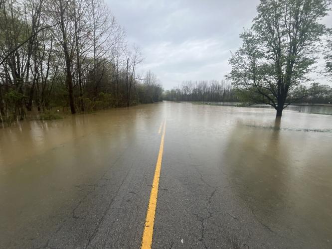
- This is a potentially life-threatening situation. Widespread areal flooding and river flooding are occurring.
- Flood waters will continue to rise into next week before finally cresting mid-week.
MSD Update:
- Metropolitan Sewer District officials say due to the recent heavy rainfall, the sanitary sewer system has reached its capacity, and they need your help.
- To prevent further complications, MSD is asking residents to refrain from using large amounts of water that flow into the sewer system—please delay using your washing machine or dishwasher.
- MSD is currently receiving a high volume of calls regarding sanitary backups. If you are experiencing a backup, please wait until the rain subsides to see if the water levels decrease. Once the rain has stopped, and if the water does not recede, please contact MSD at 502-540-6000.
- Never walk through flooded waters. Keep children and others out of flood waters. Sewer drains and manhole covers can become dislodged by flood waters and cause a serious hazard to those in the waters.
Shelters:
- At this time, pre-planned shelters are on standby for possible activation.
- Should the need for shelters arise, additional information will be provided through LENSAlert, social media, and local media.
Flood Warnings:
- A reminder: LENSAlert utilizes warning automation to deliver the fastest possible life-saving information.
- Warnings are issued by the National Weather Service in Louisville; not Louisville Metro.
- If multiple warnings are issued by our partners at the NWS - multiple alerts will be sent automatically by LENSAlert.
Mayor Greenberg update
3:15 p.m., Friday
Louisville Mayor Craig Greenberg said is under a flood warning and flash flood warning issued by the National Weather Service with more rain in the forecast through the weekend.
Tips to protect yourself and others from flooding dangers:
- Sign up to receive emergency notifications via “LENSAlert.” It’s as simple as texting “LENSAlert” to 67283.
- Turn around, don’t drown! – Most flood deaths occur in vehicles. Turn around if you come across a flooded path.
- Pay attention to road closures and do not try to go around or move barricades. They are there for a reason.
- Evacuate when advised by authorities or if you are in a flood-prone area. Get to higher ground.
- Make a family emergency communication plan that includes pets.
- Assemble an emergency kit for home, work and the car.
- Stay informed by tuning in to local officials by radio, TV or social media.
- If residents observe a storm drain that is being blocked by debris, they are encouraged to remove the debris **only if it is safe to do so**. They can also report blocked storm drains by calling 311.
- After a flood, avoid walking in floodwaters, disaster areas and heed road closure and cautionary signs. Stay away from electrical utility equipment and wait for the “all clear” before returning to a location impacted by flooding.
- If your street is flooding and it has not been closed make a report by calling 311 or call MSD at 540-6000.
- Check on your neighbors to make sure they’re OK.
Weather Forecast | Live Cams | Radar | Share Photos & Videos
City of New Albany Wastewater Department
Residents in New Albany are asked to reduce their impact on the wastewater system Saturday, Sunday and Monday by reducing large amounts of water usage when possible. It will help reduce the strain on pump stations and wastewater plants.
People can limit large water usage appliances like dishwashers, washing machines and other appliances that use large amounts of water.
MSD asks that you don't use washing machines and dishwashers
3 p.m., Friday
Louisville residents are being asked not to use their dishwashers and washing machines. In a social media post, Louisville MSD said, "Due to the recent heavy rainfall, Louisville MSD’s sanitary sewer system has reached its capacity, and we need your help. To prevent further complications, we are asking residents to refrain from using large amounts of water that flow into the sewer system—please delay using your washing machine or dishwasher.
Gov. Beshear to give weather update
Friday, 2:20 p.m.
Kentucky Gov. Andy Beshear will hold a 3 p.m. virtual briefing to update the state's response to severe weather. Jim Gray, secretary, Kentucky Transportation Cabinet, and Eric Gibson, director, Kentucky Emergency Management, will also give updates.
Mayor Greenberg to give weather update
Friday, 2 p.m.
Louisville Mayor Craig Greenberg will hold a news conference at 3 p.m. updating the city on flooding. Representatives from the Metropolitan Sewer District, Metro Emergency Services and Metro Public Works will also be in attendance. To watch live at 3 p.m., click here.
President Donald Trump approved federal disaster assistance for Kentucky to help the state in disaster relief efforts after the week of storms. The U.S. Federal Emergency Management Agency can now coordinate efforts, which will include the ability to mobile resources quickly. The assistance will cover all 120 Kentucky counties, if needed.
MSD installing flood walls in Louisville
1 p.m., Friday
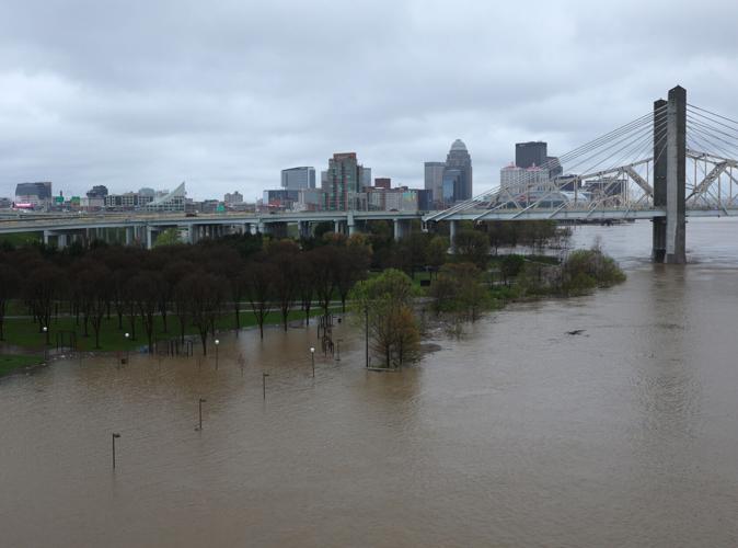
Louisville MSD is installing additional roadway floodwall closures Friday as Ohio River level projections rise. New closures today include Second Street, Bingham Way, and Port Road. On Thursday, crews installed the closures at 10th and 27th streets. Projections now show the river will crest on Monday, April 7 at 33.7 feet on the upper gauge and 65.6 feet on the lower gauge.
List of flooded roadways in Louisville
2 p.m., Saturday
Flooded/high water street closings from Louisville Metro Police. These will likely update through the day. Here's a link.
April 5, 2025 - until the flood waters recede
- Mockingbird Valley Road from River Road to Mellwood Avenue
- Alta Vista Road from Lexington Road to Beargrass Road
- National Turnpike from Mount Holly Road to Fairdale Road
- Grade Lane from Melton Avenue to Outer Loop
- Frankfort Avenue from River Road to Story Avenue
- Six Mile Lane at Breckenridge Lane
- Campbell Street from East Water Street to Adams Street
- North Campbell Street from Adams Street to Franklin Street
- North Campbell Street from Adams Street to Geiger Street
- Lower River Road from West Orell Road to Watson Lane
- Indian Hills Trail from River Bluff Road to River Road
- Katherine Station Road from Dixie Highway to bridge
- Adams Street from Cabel Street to East Witherspoon
- Witherspoon from North Shelby Street to River Road
- Beargrass Road from Alta Vista Road to Barrett Hill Road
- West River Road from North 3rd Street to North 8th Street
- West River Road from Bingham Way to North 7th Street
- North 2nd Street from East Witherspoon Street to West River Road
- North 6th Street from West Washington Street to West River Road
- North 4th Street from West Main Street to West River Road
- North 3rd Street from West Main Street to West River Road
Weather Forecast | Live Cams | Radar | Share Photos & Videos
Louisville Fire water rescues
9:40 a.m., Friday
From Louisville Fire Department Capt. Donovan Sims:
- At 11:30 p.m. last night Louisville Fire Department rescue crews were dispatched to reports of a vehicle stuck in water in the 800 Block of W Oak. Upon arrival crews found one vehicle stalled in standing water under the 9th street ramp at west oak. Companies were able to quickly rescue one adult female and three children. No injuries were reported from the incident.
- Last night at 9:00 p.m., the Louisville Fire Department deployed a swift water rescue team to Casey County (Liberty, Kentucky) to assist with emergency response efforts. The team is currently on standby with the Liberty Fire Department, awaiting assignment. Updates on their efforts will be provided as they become available.
West Point, Kentucky asks sightseers to stay away
8:30 a.m., Friday
The City of West Point, Kentucky, is concerned about flooding. The city posted an advisory on social media asking sightseers to stay away. The post said, "Residents are moving their possessions to higher ground and we don't need any additional traffic."
Town of Palmyra under boil water advisory
All Palmyra water customers are under a boil water advisory due to a water main break.
"We apologize for the inconvenience," the Town of Palmyra posted on Facebook.
I-69 road closure in Daviess County
Interstate 69 in Daviess County in southern Indiana has closed due to high water.
The I-69 southbound closure goes from SR58 E to US231 S to US50 W. The I-69 northbound closure goes from US50 E to US231 N to SR58 W.
Indiana State Police will update the public when the interstate is back open.
Caesars Southern Indiana temporarily closes
Caesars Southern Indiana has temporarily closed due to rising flood waters.
Flooding near Mammoth Cave National Park
5 p.m., Thursday
Mammoth Cave National Park said on social media there is flooding along the Green River.
Due to anticipated high-water levels in the Green River, Mammoth Cave National Park will temporarily close the following river access areas and roads starting the following dates:
- Friday, April 4
- Green River Ferry – Vehicle ferry operation
- Saturday, April 5
- Dennison Ferry Day Use Area and Dennison Ferry Road
- Houchin Ferry Campground and Houchin Ferry Road
- Green River Ferry Road from the intersection with Mammoth Cave Parkway to the intersection of Maple Springs Campground
Closures will be in place until river levels recede, park staff can clean up flooded facilities, and visitor operations can safely resume.
More Top Stories:
- FEMA deploys resources to Kentucky after President Trump approves emergency declaration
- Thunder Over Louisville canceled due to flooding
- City officials preparing for possibility of top-10 flooding event in Louisville's history
- Local hardware stores see influx of customers gathering supplies to clean up after flooding
- Mudslide closes lane of Gene Snyder Freeway near Fairdale
- Jeffersontown apartment residents were scrambling as severe storm tore through complex
- State of emergency declared in Louisville after tornado with major flooding expected
- Storms in southern Indiana leave twisted trail of damage and downed power lines
- Tornado leaves extensive damage, thousands without power in east Louisville
Copyright 2025 WDRB Media. All Rights Reserved.


